

The 2026 release of the Surface Ocean CO2 Atlas (SOCAT) marks a landmark moment for ocean carbon science, and for the TRICUSO project. With 44 million quality-controlled measurements now publicly available, SOCAT v2026 offers an unprecedented window into the health of the ocean carbon sink. At the same time, the metadata underpinning this release provides TRICUSO with something equally valuable: a clear map of the global observing fleet that will form the backbone of the emerging Surface Ocean CO2 Observing Network (SOCONET).

High-quality synthesis for ocean CO₂ sink quantification
The ocean absorbs roughly 3.2 petagrams of carbon per year—equivalent to 29% of all human CO2 emissions. Without this vast carbon sink, atmospheric CO2 levels and the pace of climate change would be considerably higher. Quantifying exactly how much carbon the ocean takes up, and tracking how that capacity may be changing, depends on one essential resource: sustained, high-quality measurements of the partial pressure of CO2 (pCO2) at the ocean surface.
SOCAT is the global synthesis that makes this possible. Since its first public release in 2011, it has aggregated in situ surface ocean pCO2 measurements from data providers around the world, subjected them to rigorous quality control, and made them freely available. SOCAT v2026 adds 394 new datasets and updates 19 more, bringing the total archive to 44 million measurements spanning the period 1957–2025.

"Ocean CO₂ uptake has exceeded land CO₂ uptake by 30% over the past decade. The community-led SOCAT synthesis is key for quantification of ocean CO₂ uptake, thus providing vital information for climate policy".
SOCAT v2026 release announcement
The initial effort to define the SOCONET inventory is concentrated on SOCAT’s highest-quality datasets, giving the network a strong technical foundation from the outset. At the same time, a tier system is being developed within SOCONET to recognise, and in time accommodate, datasets of varying accuracies. This phased approach lets the network establish itself on solid ground now, while keeping a clear path open for the wider observing community to join as SOCONET matures.
A global fleet of observing platforms
As part of TRICUSO Milestone 27, the project undertook a systematic identification of the platforms contributing data to SOCAT v2026. This catalogue forms the empirical foundation for defining SOCONET— establishing which vessels, moorings, and uncrewed systems are already active in surface ocean CO2 monitoring and can be brought under a formal governance framework.
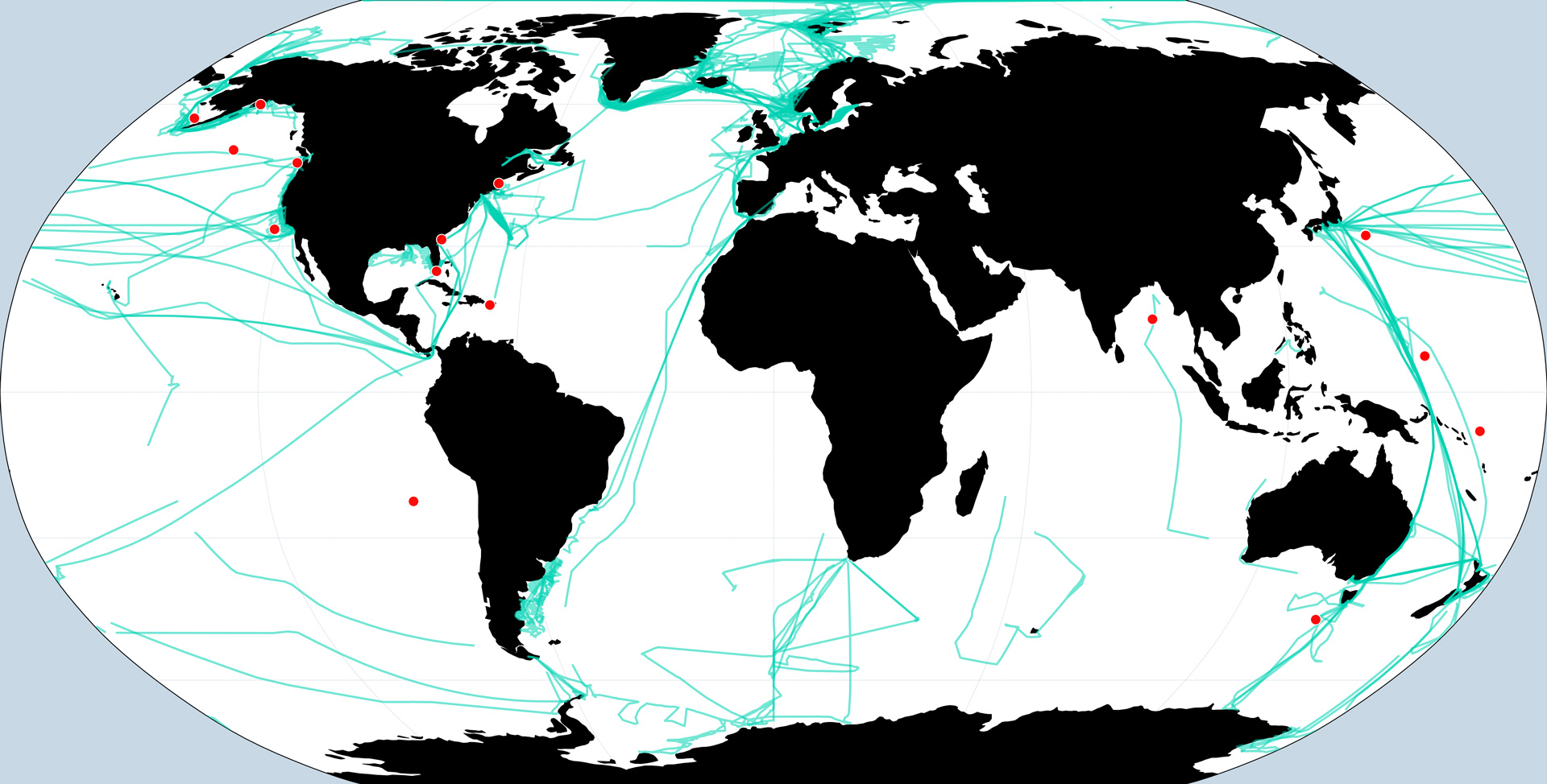
The analysis of SOCAT v2026 metadata reveals a rich and diverse observing fleet: 54 unique platforms comprising 38 ships and 15 fixed mooring sites. Together, these platforms generated over 2.9 million high-quality, new observations added in the 2026 release cycle.
Ships and vessels
The workhorse of the SOCAT data product is the underway pCO2 system fitted to ships. These range from dedicated polar research icebreakers to commercial cargo vessels and ferries operating on fixed routes. In SOCAT v2026, ships account for the vast majority of new data, with vessels operating in virtually every ocean basin.
Notable contributors include the following: the German research icebreaker Polarstern (Alfred Wegener Institute), which provided data from both polar extremes including high-latitude Southern Ocean and Arctic cruises; the Australian RV Investigator (IMOS/CSIRO) operating in the Southern Ocean and Tasman Sea; the Norwegian Kronprins Haakon (Norwegian Polar Institute) measuring in the Arctic; and the US NOAA fleet including Sikuliaq, Healy, Gordon Gunter, Henry B. Bigelow, Bell M. Shimada, Oscar Dyson, and the Nathaniel B. Palmer operating from the Gulf of Mexico to Antarctic waters.
High-frequency ferry routes provide continuous time-series coverage of key ocean regions. These include: the Finnmaid (Leibniz IOW), which traverses the Baltic Sea on near-daily crossings. The New Century 2 and Trans Future 5 (NIES Japan), which cross the Pacific repeatedly throughout the year. The Sea-Cargo Express (Norwegian) links Scandinavia to the UK; and the MV Oleander (BIOS) runs regular transects across the western North Atlantic. These Ships-of-Opportunity lines (SOOP) deliver exceptional temporal resolution at comparatively low cost.
Fixed moorings
Fifteen fixed mooring sites contribute time-series data to SOCAT v2026, the pCO2 systems of which are all managed by NOAA PMEL. These include iconic locations such as Station Papa (145°W, 50°N) in the North Pacific, the KEO mooring (145°E, 32°N) in the North Pacific subtropical region, the Stratus mooring (85°W, 22°S) in the Southeastern Pacific, and SOFS (142°E, 47°S) in the Southern Ocean. Together, these moorings provide invaluable continuous records that are critical for understanding seasonal and interannual variability in air-sea CO2 exchange.
Coverage, gaps, and the case for SOCONET
The SOCAT v2026 platform catalogue is impressive in its breadth, but it also reveals the challenge SOCONET must address. Coverage is strongest in the North Atlantic and North Pacific, where established research fleets and shipping routes provide good spatial and temporal density. Coverage is considerably thinner in the Southern Hemisphere, the Indian Ocean, the Pacific south of 30°S, and the Arctic Ocean.
This unevenness in the observing network is not merely an academic concern. The Southern Ocean alone accounts for a disproportionate share of global ocean carbon uptake, yet it remains one of the most poorly observed regions on Earth. Seasonal ice cover, harsh sea states, and the limited presence of research vessels or commercial shipping routes all conspire to keep data sparse precisely where understanding is most critical.
"Surface ocean pCO₂ data availability is low in the Southern Hemisphere, the Indian Ocean, the Pacific Ocean south of 30°S, and the Arctic Ocean. With the importance of constraining ocean CO₂ uptake well recognized by the WMO Global Greenhouse Gas Watch (G3W) and the UNFCCC Global Stocktake, there is an urgent need for sustained funding of accurate surface ocean CO₂ measurements".
SOCAT v2026 release announcement
From platform inventory to formal network: TRICUSO's role
SOCAT has operated for over a decade as a community-driven, volunteer effort—an extraordinary achievement that has delivered significant value to climate science. However, it has done so without core funding, without a formal legal structure, and without the institutional recognition that sustained long-term commitments require. TRICUSO Task 6.2 exists to change that.
The platform identification carried out under Milestone 27 is a foundational step. By cataloguing the ships, moorings, and institutions already contributing to SOCAT, TRICUSO can now define the membership and scope of SOCONET—the formal Surface Ocean CO2 Observing Network to be operated under WMO auspices and eventually displayed on the OceanOPS dashboard.
The next steps build directly on this inventory. Subsequent milestones will establish an international Steering Committee for SOCAT, create formal links to institutional sponsors including ICOS, IODE, GOOS, and IOCCP, and develop the governance documentation needed to secure sustained funding. Platform operators identified in this milestone will be key partners in that process.
For the observing community comprising project investigators, data managers, and institutions listed in the SOCAT v2026 metadata, this represents a pathway from the current ad hoc model to something more durable: a recognized network, with clear governance, that can advocate for the sustained resources the observing system needs.
Looking ahead
The annual SOCAT release cycle is both a product and a demonstration of what a functioning observing network looks like. Fifty-four platforms, 44 million measurements: this is the ocean CO2 observing system as it exists today—largely informal, substantially voluntary, and yet indispensable.
TRICUSO Milestone 27 has taken stock of this reality and documented it in the form of a structured platform inventory. That inventory will guide the governance work ahead: ensuring that the institutions and vessels that make SOCAT possible are recognised, supported, and sustained as formal members of SOCONET.
Keeping accurate track of the ocean carbon sink and doing so year after year, in all ocean basins, through changing seasons and changing climates demands exactly the kind of coordinated, well-governed observing network that TRICUSO is working to build.
Further information
SOCAT v2026 download and documentation: socat.info
SOCONET – Surface Ocean CO2 Observing Network: ioccp.org/soconet
Milestone story written by Kevin O’Brien (OceanOps)


