
Accurate estimates of the ocean carbon sink are essential for policymakers to design effective climate mitigation strategies, yet these estimates remain uncertain due to sparse observational coverage in the Southern Ocean. To improve these estimates, recent efforts have turned to a novel platform: citizen science sailing yachts participating in sports challenges, opportunistically equipped with underway sensors able to measure CO2 in the remote Southern Ocean, which is otherwise difficult and costly to reach with conventional vessels. Building on this, fishery vessels are now being explored as another novel observing platform.
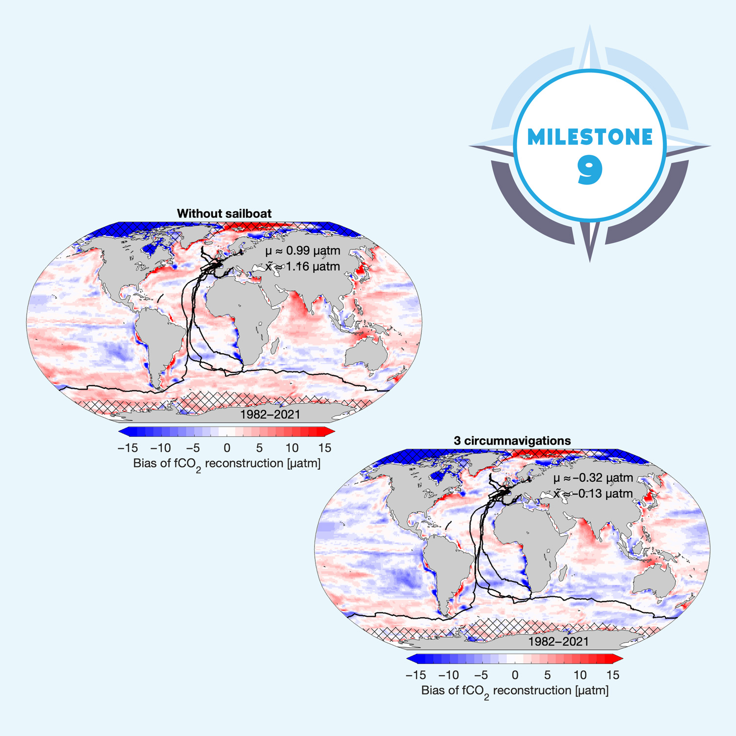
TRICUSO’s Milestone 9 sees the delivery of a diagnosis of an optimal sailing yacht equipment fitting strategy. Led by partner VLIZ within Work Package 3, the work is informed by the Behncke et al. (2026) published study Improved air-sea CO2 flux estimates from sailboat measurements; in addition this report includes preliminary exploration of fishing vessels as another novel platform to extend ocean observation.
Towards an optimal observing system: citizen science sailing yachts as an ocean CO₂ monitoring platform to improve the ocean carbon sink estimate
The team ran simulations to quantify how citizen science sailing yachts contribute to improving Southern Ocean carbon sink estimates, addressing three questions:
- What is the value of existing yacht observations?
- What is the added value of re-equipping yachts in repeating round-the-world races to strengthen decadal coverage?
- What extent do random uncertainties and systematic biases from membrane-based sensors degrade these improvements?
Key results:
- Existing sailing yacht data (2018–2021, including one round-the-world race) did not substantially improve the global carbon sink estimate.
- Using the existing observing network tracks (SOCAT), the SOM-FFN machine learning method underestimates the ocean carbon sink relative to the HAMOCC model truth.
- Two additional round-the-world races improve the global mean sink estimate, particularly in the Southern Ocean between 40°S and 60°S.
- While random measurement uncertainties associated with the yacht data do not undermine these results, systematic biases can significantly distort results, particularly in the underobserved Southern Ocean in the most recent years.
- Even with additional yacht data, the long-term CO2 sink trend remains overestimated, highlighting the need for continued and sustained observations.
An observing system simulation experiment: the tool to test different sampling strategies
To test whether sailing yacht data improve ocean carbon sink estimates, the team used an observing system simulation experiment (OSSE). Rather than relying on real observations where true ocean carbon uptake is never fully known, they used the HAMOCC ocean biogeochemical model as a stand-in for reality. Subsampling this model at the times and locations of real or hypothetical yacht measurements, then reconstructing the global CO2 field with the SOM-FFN machine learning algorithm, allowed a direct comparison against known model truth. Both tools feed into the Global Carbon Budget, the international benchmark used by policymakers to monitor ocean carbon uptake, so any demonstrated improvement carries direct policy relevance.
How repeated round-the-world measurements bring us closer to the true ocean carbon sink
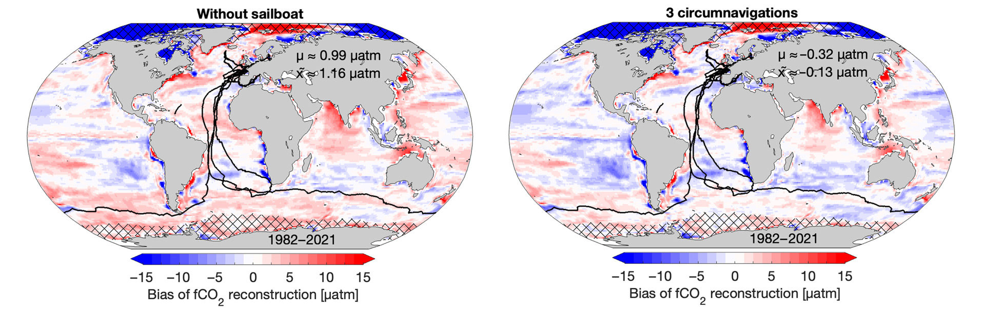
Using the existing observing network alone (meaning tracks from the SOCAT database), the SOM-FFN machine learning method already underestimates the ocean carbon sink relative to the model truth. Adding the sailing yacht data collected between 2018 and 2021, which includes one Vendée Globe round-the-world race, does not substantially change this. The number of added sailing yacht data is too small and their addition to the dataset is too recent to make a detectable improvement at the global scale.
However, adding two additional round-the-world races to the simulation does improve the global mean carbon sink estimate by increasing the uptake estimate, particularly in the Southern Ocean between 40°S and 60°S, which is the region where observational gaps are largest and uncertainty highest (Fig. 1). This is because the additional round-the-world races provide repeated coverage of the Southern Ocean, giving the machine learning algorithm enough new information to better characterise the CO2 distributions. As a result, the improvement is not limited to the regions where the sailing yachts actually sailed; the algorithm extrapolates the new information across the full ocean, improving estimates in other data-sparse regions as well (Fig. 1). However, this comes with regional trade-offs, as the algorithm’s adjustment of the global mean can worsen estimates in other regions, e.g., in the South Pacific (Fig. 1).
How sensitive are the ocean carbon estimates to measurement errors in yacht data? The importance of calibration and data quality
In the real world, measurements always come with some degree of uncertainty or bias. For the 2026 study cited above, the team tested two types of measurements: random uncertainties, at ±5 μatm (the previous quality threshold for membrane-based sensors) and ±10 μatm (a more realistic estimate from a recent intercomparison study) and systematic biases, representing a constant offset simulating insufficient calibration.
Random measurement uncertainties, even at the higher end, do not undermine the improvements. Systematic biases tell a more complex story. While a negative bias worsens the carbon uptake estimate as expected, particularly in data-sparse regions like the Southern Ocean and in the most recent years, a positive bias can actually appear to improve it, however misleadingly: the offset accidentally compensates for undersampling of high-fCO2 regions, shifting the reconstruction toward model truth for the wrong reason. That a systematic bias can distort carbon uptake estimates underscores the need for climate-quality data and continued instrument improvement.
The need and possibility for multidecadal observing strategies: sailing yachts as part of a sustained multi-platform network
Despite the improvements brought by two additional round-the-world races, one critical limitation remains: the long-term trend in Southern Ocean CO2 uptake continues to be overestimated. The machine learning algorithm likely requires observations spanning multiple decades to accurately reproduce this trend, something individual racing events cannot yet provide.
Closing this gap requires a sustained commitment to sailing yacht observations. Regular round-the-world races such as the Vendée Globe and The Ocean Race, which together operate a major race approximately every two years, offer a realistic strategy, and are complemented by biogeochemical floats and autonomous surface vehicles that provide year-round data where sailing yachts cannot. Behncke et al. (2026) demonstrate that continued investment in equipping sailing yachts with CO2 sensors is both valuable and feasible, with its value only expected to grow as the observational record accumulates.
Preliminary key results:
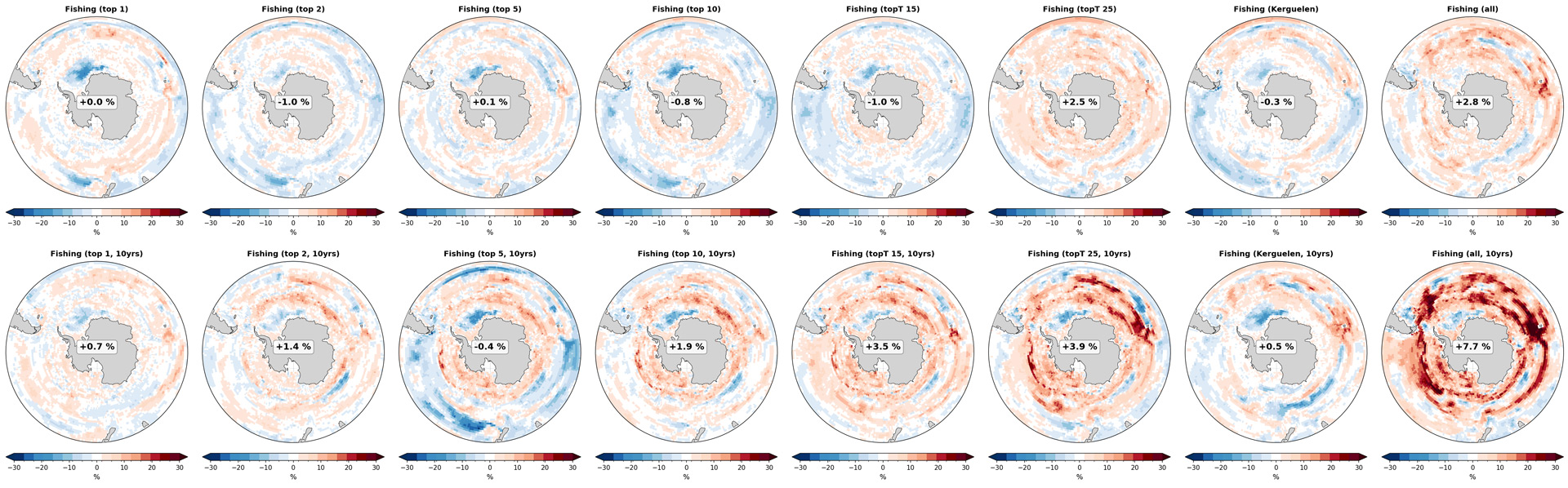
- Equipping a Southern Ocean fishing fleet (106 vessels) active during 2017–2020 improves the Southern Ocean flux reconstruction by 2.8% on average (up to 7.7% over 10 years), with substantial improvement in austral winter.
- The Kerguelen fleet represents an effective option for regional improvement, reaching +8.7% within the Kerguelen sector over 10 years, but contributes little to basin-scale Southern Ocean reconstruction skill.
- Targeted sensor equipment of specific fishery vessels (selecting 1, 10, 15, or 25 vessels, or the Kerguelen fleet) yields limited improvement over 3 years due to spatial extrapolation trade-offs in the neural network, but becomes increasingly effective with sustained 10-year sampling.
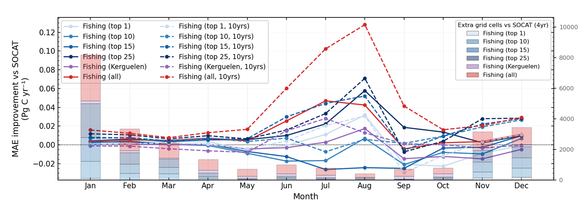
Fishing vessels operating year-round offer a key advantage over other platforms with their near-continuous sampling including austral winter. In an ideal scenario where 106 Southern Ocean fishing vessels active in 2017, 2019, 2020 were equipped with underway fCO2 sensors, we find an average MAE improvement of 2.8% over 2013–2024 (south of 40°S), with local improvements reaching up to 14.6% (Fig. 2). Extending this deployment to 10 years yields an average improvement of 7.7% (locally up to 44.8 %, Fig. 2), with the strongest improvement in austral winter, up to 0.13 Pg C yr⁻¹ in August (Fig. 3).
Examining more feasible scenarios, the team ranked vessels by their potential contribution and evaluated targeted subsets of 1, 2, 5, 10, 15, and 25 vessels. Over the standard three-year period, equipping 25 vessels yields a 2.5% improvement, while smaller subsets with less equipped vessels show only slightly improved or even worse performance. This reflects a fundamental limitation of the SOM-FFN gap-filling method: adding observations in one region can simultaneously improve estimates locally while degrading them elsewhere through spatial extrapolation, a trade-off that is amplified when coverage is sparse and unevenly distributed. Targeted deployment in regions of high residual variance is therefore critical, as the neural network learns primarily from well-sampled areas and its extrapolation into data-sparse regions can introduce compensating errors. Extending the sampling period to 10 years substantially improves reconstructions, with average Southern Ocean improvements of 0.7% (1 vessel), 1.9% (10 vessels), 3.5% (15 vessels), and 3.9% (25 vessels), (Fig. 2).
A specific case examined is the Kerguelen Islands fishing fleet consisting of eight sustainable Patagonian toothfish fishery vessels, identified as particularly approachable to onboard data collection. Equipping these vessels for only three years results in a slightly worse performance in the Southern Ocean (−0.3%) despite local improvement, but extending deployment to 10 years yields a 2.5% improvement, highlighting the importance of sustained observation records for constraining neural network reconstructions (Fig. 2).
Taken together, these results demonstrate that fishing vessels represent an untapped, cost-effective platform with strong potential to close the critical winter sampling gap in the Southern Ocean; a period when current estimates diverge on the magnitude of CO2 outgassing and direct observations remain exceptionally sparse.
This milestone contributes to Key Exploitable Results 5 and 6, which together aim to describe what the optimal observing system looks like based on novel platforms and to develop a broad strategic approach to the Global Ocean Observing System (GOOS).
Milestone story written by Jacqueline Behncke (GEOMAR).
For more detailed information, check out the papers below.
References
- Behncke, J., Ilyina, T., Chegini, F., and Landschützer, P. (2026) Improved air-sea CO₂ flux estimates from sailboat measurements. Science Advances 12, eadz1502. DOI: 10.1126/sciadv.adz1502
- Behncke, J., Landschützer, P. & Tanhua, T. A detectable change in the air-sea CO₂ flux estimate from sailboat measurements. Sci Rep 14, 3345 (2024). https://doi.org/10.1038/s41598-024-53159-0
- Friedlingstein, P., O’Sullivan, M., Jones, M. W., Andrew, R. M., Hauck, J., Landschützer, P., Le Quéré, C., Li, H., Luijkx, I. T., Olsen, A., Peters, G. P., Peters, W., Pongratz, J., Schwingshackl, C., Sitch, S., Canadell, J. G., Ciais, P., Jackson, R. B., Alin, S. R., … Zeng, J. (2025). Global Carbon Budget 2024. Earth System Science Data, 17(3), 965–1039. https://doi.org/10.5194/essd-17-965-2025
- Landschützer P, Tanhua T, Behncke J, Keppler L. (2023) Sailing through the southern seas of air–sea CO₂ flux uncertainty. Phil. Trans. R. Soc. A 381: 20220064. https://doi.org/10.1098/rsta.2022.0064
- Steinhoff, T. , Gkritzalis, T., Jones, S., Macovei, V., Neill, G., Schuster, U., Akl, J., Arruda, R., Atamanchuk, D., Barry, M., Beaumont, L., Cantoni, C., Dickson, A., Fahning, J., Fought, J., Frangoulis, C., Gutiérrez-Loza, L., Hagan, C., Honkanen, M., Kielosto, S., Kinski, N., Körtzinger, A. , Landschützer, P., Lauvet, S., Lawrence-Slavas, N., Li, Q., Luchetta, A., Malarde, D., Paulsen, M., Ritschel, M., Rutgersson, A., Sanders, R., Shitashima, K., Spaulding, R., Stamataki, N., Stenbäck, K., Sutton, A., Tatkiewicz, W., Telszewski, M., Theetaert, H., Tilbrook, B. und Wanninkhof, R. (2025) The ICOS OTC pCO₂ instrument intercomparison. Open Access Limnology and Oceanography: Methods, 23 (12). pp. 924-948. DOI 10.1002/lom3.10727.


